Lost pub · Drumburgh
The Lowther Castle Inn
- Gone
- Closed by the Board, 1917
- There now
- A house, Lowther House
- Address
- Drumburgh
- Where exactly
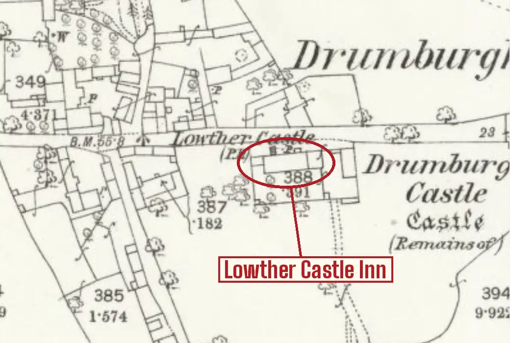
- Placed from the Ordnance Survey grid reference, NY2650759786, in Historic England's gazetteer of the scheme's premises. The 25-inch map surveyed in 1864 marks the Lowther Castle (P.H.) here. The building's use in 2018: residential (Lowther House).
The village inn at Drumburgh, on the Solway on the line of Hadrian's Wall, a few yards along the road from the remains of Drumburgh Castle. Its sign was a compliment to the lord of the manor: the Earls of Lonsdale, whose seat was Lowther Castle, held the manor of Drumburgh, and land here was still held of the Earl by customary tenure in the 1840s. The Ordnance Survey's 25-inch map surveyed in 1864 marks the Lowther Castle (P.H.) on the south side of the village street.
It was already the place where the village met. In November 1819 the Drumburgh Annual Hunt cast off at seven in the morning, with dinner 'upon the Table precisely at Two in the Afternoon, at Joseph Wood's, the Lowther Castle Inn'. Benjamin Wood kept it in 1841, when an estate at Glasson was auctioned there, and the Woods of Easton still owned it in the 1860s and 1870s. When the Carlisle and Silloth Bay Railway was cut across Drumburgh Moss, the commoners were called to the inn in September 1855 to choose a committee to treat with the company for their lost rights, and in March 1857 the magistrates sat there, at Jeremiah Skelton's, to hear the Lawsons of Drumburgh Castle claim for damage to their crops.
It was more than an inn. Every letting notice offers it with a grocer's shop, farm buildings and about twenty acres of land, with the right to graze over the undivided common and to cut peats on the moss. In 1867 the Woods described it as 'in a district surrounded by Public Works', and in 1873 as in 'a thriving locality, surrounded by large and increasing Chemical and Manure Manufactories', an unexpected view of a Solway village. In 1886 the valuer regulating Drumburgh Common and Moss deposited his schedule of everyone's claims at the inn for the parish to inspect.
In 1891 its licence was moving from J. G. Milburn to Thomas Thwaites when the freehold came up for auction at the Caledonian Hotel in Carlisle: the inn, with yard, stables, byre and coach-house, a cottage 'for many years used as a Grocer's Shop', fifteen acres and a quarter, a customary close called Marsh Close, a stint and a quarter on Drumburgh Moss and two peat pots. It stood 'in the centre of the pleasant village of Drumburgh', a few minutes' walk from the station, the licence was 'one of very long standing', and it was let at £65 a year. In November 1898 the licence passed from William Jefferson to John Connell, formerly dairy farm manager to Mr Black of Hensingham Hall.
In August 1899 the coroner sat there on William Fox, a farmer from High Pow near Bolton, 45 and three times married, who had walked out on the marsh after Sunday dinner, stripped near Glasson Creek and gone into the tide though he could not swim. The jury asked for notice boards warning bathers at Raven Bank and Drumburgh jetty: what used to be level sand, the foreman said, was now a sudden drop, the channel having shifted all the way down from Rockcliffe. By 1901 it belonged to the Maryport Brewery, which advertised it to let with seventeen acres from Candlemas 1902. It was still licensed in July 1916, as the Lowther Castle, Drumburgh, and the Board closed it the next year. The building is a house now, Lowther House.
Photograph
Sources
- Historic England, Countering the 'deadliest of foes': public houses of the Central Control Board and the State Management Scheme, 1916-73 (Clare Howard, Research Report 89-2018): Appendix C, gazetteer of scheme premises
- The Cumberland News, 8 July 1916: 'First State tavern: to be opened by Lord Lonsdale', with the list of licensed houses in the Cumberland Ward and Longtown divisions (via newspapers.com)
- Carlisle Patriot, 13 November 1819, p. 1: 'Drumburgh Annual Hunt' (via British Newspaper Archive)
- Carlisle Journal, 11 September 1841, p. 2: 'Estate at Glasson' (via British Newspaper Archive)
- Carlisle Journal, 31 August 1855, p. 4: 'The Carlisle and Silloth Bay Railway and Dock Company: Drumburgh Common or Moss' (via British Newspaper Archive)
- Carlisle Journal, 6 March 1857, p. 8: 'Carlisle and Silloth Railway: compensation for damages' (via British Newspaper Archive)
- Carlisle Journal, 23 August 1867, p. 8: 'The Lowther Castle Inn, and land at Drumburgh, to let' (via British Newspaper Archive)
- Carlisle Patriot, 29 August 1873, p. 1: 'Lowther Castle Inn, Drumburgh, to let' (via British Newspaper Archive)
- Carlisle Patriot, 30 April 1886, p. 4: 'Drumburgh Common and Moss regulation' (via British Newspaper Archive)
- North Cumberland Reformer, 12 February 1891, p. 6: 'The Courts, Carlisle', licence transfers (via British Newspaper Archive)
- Carlisle Patriot, 27 March 1891, p. 1: preliminary announcement of sale (via British Newspaper Archive)
- Carlisle Patriot, 8 May 1891, p. 1: 'Old established freehold publichouse, with shop and land adjoining, in Drumburgh' (via British Newspaper Archive)
- Carlisle Journal, 22 November 1898, p. 4: 'The Courts', licensing business (via British Newspaper Archive)
- Carlisle Journal, 1 September 1899, p. 6: 'The bathing fatality at Drumburgh' (via British Newspaper Archive)
- East Cumberland News, 23 November 1901, p. 1: 'To let, Lowther Castle Inn, Drumburgh' (via British Newspaper Archive)
- Ordnance Survey 25-inch map, Cumberland XV.10, surveyed 1864, via the National Library of Scotland
Still serving, near where it stood
-
1.4 kmaway
-
4.2 kmaway
-
5.9 kmaway
-
7.3 kmaway